 My Old Logitech headset actually broke. Went hunting for a replacement. Finally purchased this Sony Ericsson iv-835 Bluetoooth Headset via an internet dealer.
The greatest thing about it is that it uses the same charger as my W810i. No more necessity of carrying more chargers while travelling, and I get a spare charger.
Besides that, the usual technical geektalk, Bluetooth 2.0, DSP, tiny form factor.
Stuff i noticed after i got it, Its got no loop over the ear, but its light enough to stuff into the ear canal. I had to use the largest ear bud. Its rather comfortable, but seriously, not snug enough to go jogging with. A small amount of headbanging will definately send the headset flying.
Another point to note.. You CANNOT eat keropok crackers while using this headset!! Try stuffing your finger into your ear and eat the keropok crackers, the feedback is LOUD!
Also, the redial function doesn't work, even with my w810i. Gonna email sony aboout it.
**update: well i finally got it to work. Have to double press the button very very fast, for the redial to work. Even after knowing to have to double press it very fast, sometimes i still don't seem to press it fast enough.**
I'm going to mod this headset soon so that i can put some sort of clip onto it to facilitate me clipping it to my shirt while working. I hate to have the headset in my ear all the time.
More pictures after i mod it.
My Old Logitech headset actually broke. Went hunting for a replacement. Finally purchased this Sony Ericsson iv-835 Bluetoooth Headset via an internet dealer.
The greatest thing about it is that it uses the same charger as my W810i. No more necessity of carrying more chargers while travelling, and I get a spare charger.
Besides that, the usual technical geektalk, Bluetooth 2.0, DSP, tiny form factor.
Stuff i noticed after i got it, Its got no loop over the ear, but its light enough to stuff into the ear canal. I had to use the largest ear bud. Its rather comfortable, but seriously, not snug enough to go jogging with. A small amount of headbanging will definately send the headset flying.
Another point to note.. You CANNOT eat keropok crackers while using this headset!! Try stuffing your finger into your ear and eat the keropok crackers, the feedback is LOUD!
Also, the redial function doesn't work, even with my w810i. Gonna email sony aboout it.
**update: well i finally got it to work. Have to double press the button very very fast, for the redial to work. Even after knowing to have to double press it very fast, sometimes i still don't seem to press it fast enough.**
I'm going to mod this headset soon so that i can put some sort of clip onto it to facilitate me clipping it to my shirt while working. I hate to have the headset in my ear all the time.
More pictures after i mod it.
Monday, November 27, 2006
Sony Ericsson IV-835 Bluetooth Headset aquisition review

Thursday, November 16, 2006
Sony Ericsson W810i New Aquisition
 Finally.. after 6 months of cotemplating, I replaced my aging almost 2 year old Sony Ericsson T630 to the newer W810i
The new W810i is Great.. Much faster Processor, and it has EDGE, which is great with DiGi, my cellphone provider. I have a small data plan for my DiGi account so edge is good for me..
Great things about the W810i:
Its got EDGE! about 384 kbps down, which is half as fast as my streamyx. Plan to use it with my notebook for wireless data access.. Costs much less than any 3G access (i think)
Walkman! Thats great, has a loud speaker too.
Upgraded Java. Allows Maybank 2u use from my mobile and also the new Gmail mobile version.
Looks Great! really.. my old T630 is aging in the aesthetics factor. Techie toys for geeky boys.
The thing i hate most: It doesn't support Bluetooth Voice answer. Even my old T630 supported it but not this newer w810i. It also doesn't support the Voice redial. Its quite a big problem for me, as this means I can't answer calls with my Bluetooth headset anymore while scrubbed up.
Still looking for a solution for this. Maybe a firmware hack may be possible.
More later then
Finally.. after 6 months of cotemplating, I replaced my aging almost 2 year old Sony Ericsson T630 to the newer W810i
The new W810i is Great.. Much faster Processor, and it has EDGE, which is great with DiGi, my cellphone provider. I have a small data plan for my DiGi account so edge is good for me..
Great things about the W810i:
Its got EDGE! about 384 kbps down, which is half as fast as my streamyx. Plan to use it with my notebook for wireless data access.. Costs much less than any 3G access (i think)
Walkman! Thats great, has a loud speaker too.
Upgraded Java. Allows Maybank 2u use from my mobile and also the new Gmail mobile version.
Looks Great! really.. my old T630 is aging in the aesthetics factor. Techie toys for geeky boys.
The thing i hate most: It doesn't support Bluetooth Voice answer. Even my old T630 supported it but not this newer w810i. It also doesn't support the Voice redial. Its quite a big problem for me, as this means I can't answer calls with my Bluetooth headset anymore while scrubbed up.
Still looking for a solution for this. Maybe a firmware hack may be possible.
More later then
Tuesday, October 31, 2006
Which Scifi Character are you?
Which Scifi character are you? follow link: which scifi character are you if you are a mypdacafe member you can follow this link to see a thread on this topic forum.mypdacafe.com
Monday, October 30, 2006
Happy Haloween!
 First time I heard about haloween must be during cartoon watching days. Since its Haloween, here's some pictures of Pumpkin growing in my backyard till it reaches my dinner table. Its not the normal white people Pumpkin you can carve into a haloween latern, i think this is some other variety.
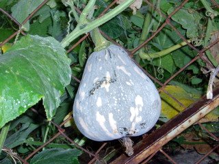 Tastes great cooked with chilli, garlic and shrimp. I wonder what happens if Malaysian kids start going trick or treating. Tommorow sure in newspapers....PONTIANAK SUNDAL MALAM KEMBALI.... ha ha
First Picture shows the pumpkin fruit with a flower. The flower withers and leaves the fruit to grow large.
Tastes great cooked with chilli, garlic and shrimp. I wonder what happens if Malaysian kids start going trick or treating. Tommorow sure in newspapers....PONTIANAK SUNDAL MALAM KEMBALI.... ha ha
First Picture shows the pumpkin fruit with a flower. The flower withers and leaves the fruit to grow large.
 Second picture shows the fruit. Not like the white people haloween pumpkin.. not so big, not so round. Third picture is the pumpkin halved. Smells really nice, like a honey dew melon. Smells so sweet raw.
This was cooked with fried shrimp, dried chilli and garlic. Tasted rather fine.
HAPPY HALOWEEN.. 31st October 2006.
Second picture shows the fruit. Not like the white people haloween pumpkin.. not so big, not so round. Third picture is the pumpkin halved. Smells really nice, like a honey dew melon. Smells so sweet raw.
This was cooked with fried shrimp, dried chilli and garlic. Tasted rather fine.
HAPPY HALOWEEN.. 31st October 2006.
 More Techie Posts in the near future, its just a food post today.
Tuesday, October 24, 2006
GPS software with Maps for Malaysia and Singapore
Global Positioning System is really taking off in Malaysia. The following is my GPS setup, A Holux GPSlim 236 bluetooth GPS receiver, and my trusty HP iPAQ hx2750 and my old phone.

Good News Everyone! I'm now a reseller for Rikaline Bluetooth GPS receiver! I'll be selling at below market price for all my blog readers. Follow this link for more info: Link to below market price Rikaline Bluetooth GPS receivers This is a list of some GPS Software with Malaysian and Singapore maps which will be compatible to any Bluetooth GPS receiver. This write up is just a brief introduction to available softwares at this time. You can use these with any Bluetooth GPS receiver and most Pocket PCs and Notebooks with bluetooth capability.
I have written about my Garmin GPS 10x with Garmin Mobile XT software on my PPC .. The short reviews are ready:
Link to the new Garmin GPS 10x review and Mobile XT compared with Garmin Que softwares
Garmin Que (Pocket PC)


iMAP from Navitech (Pocket PC)

 This has a fairly accurate map with a nice GUI. It is a clone of Mapking, But the Map has been polished up. I think they have also polished up their map so as it is now a right hand drive map. Roundabouts go clockwise. Supports 3D views. Supposedly the firm is based in Singapore. Their website is at http://www.navitech.com.my/ Trial versions of this software is available but quite difficult to obtain. Trial software is unavailable for download at their website but should be available on request. Their Maps are more detailed than Mapking, as they are newer. They're newest map is dated 15th October 2006. The interesting part of this software is that it also has the building footprint on the map as well. This is quite nice as you can actually judge the building size on the map. This software with Malaysian and Singapore Map costs about 450 ringgit on its own. However It comes bundled with Holux GPS devices purchased from Navitech.
MAPKING (Pocket PC)
This has a fairly accurate map with a nice GUI. It is a clone of Mapking, But the Map has been polished up. I think they have also polished up their map so as it is now a right hand drive map. Roundabouts go clockwise. Supports 3D views. Supposedly the firm is based in Singapore. Their website is at http://www.navitech.com.my/ Trial versions of this software is available but quite difficult to obtain. Trial software is unavailable for download at their website but should be available on request. Their Maps are more detailed than Mapking, as they are newer. They're newest map is dated 15th October 2006. The interesting part of this software is that it also has the building footprint on the map as well. This is quite nice as you can actually judge the building size on the map. This software with Malaysian and Singapore Map costs about 450 ringgit on its own. However It comes bundled with Holux GPS devices purchased from Navitech.
MAPKING (Pocket PC)
 Brother of iMAP, Mapking Version 7 is one of the leading GPS software, and is also bundled with HP GPS enabled Pocket PCs. Their maps are not as accurate as iMAP as they are slightly older. Their roundablouts go anticlockwise due to the taiwanese influence. Creates some havoc at highway ramps. Their most recent Malaysian map upgrade is in March 2006. Trial versions are available from their website at http://www2.mapking.com/en/MK7/MK7_Dowload_Eng.htm
A new mapking Version G10 is also out. It looks similar to the maps from Navitech, but the Map version for Malaysia is still the same maps as from Version 7. So newest "Mapking Style" maps are still from iMAP Navitech.
Brother of iMAP, Mapking Version 7 is one of the leading GPS software, and is also bundled with HP GPS enabled Pocket PCs. Their maps are not as accurate as iMAP as they are slightly older. Their roundablouts go anticlockwise due to the taiwanese influence. Creates some havoc at highway ramps. Their most recent Malaysian map upgrade is in March 2006. Trial versions are available from their website at http://www2.mapking.com/en/MK7/MK7_Dowload_Eng.htm
A new mapking Version G10 is also out. It looks similar to the maps from Navitech, but the Map version for Malaysia is still the same maps as from Version 7. So newest "Mapking Style" maps are still from iMAP Navitech.
Handymap AI Gold (Pocket PC) Similar to Mapking and iMAP in its presentation, this new software reads all mapking G10 maps as well as iMap maps. So if you're going to install 1 "Mapking like" software this is the one to install. I have it in my PPC, and it also reads all the Malaysian Mapking style maps from MalsingMaps.com
MioMap/iGo (Pocket PC)


This software is originally meant for the Mio PPC but after some tweaking, currently it works on most Pocket PCs. wm2003se as well as WM5. This is actually a clone of the iGO software and all map upgrades will be handled by iGO. The MioMap V 3.2 uses iGO 2006 maps. This software has an Excellent looking map. Best 3D views available. But the map coverage is so so. You can find some POIs and roads with it. But its an excellent software to show off with.Supposedly it can actually find places with the postcode, but however, that doesn't work with Malaysian maps.
AGIS Navigator (Pocket PC)

 The maps are not very detailed at all. One nice function that it has a direction arrow, so if you mark a certain location, there will be a line perpetually pointing to that location. (Some sort of beeline thing. Sooner or later, you'll reach your location. I can see it being very usefull in off road tracking. Otherwise, city routing is difficult. Their website is at http://www.asiagis.com.sg/ and they seems to be producing many new promising products.
GPS Tuner (Pocket PC)

 This software doesn't come with Maps, but i've included this as you can make your own maps for this. It marketed as a GPS software solution for Off-Road use. Its great for off road use. With Google earth, you can make your own map, and the off road terrain can be quite clearly made out. See the topic on how to make the maps here:
Garmin nRoute (Notebooks, Carputers and PCs)
 Garmin Nroute is the most excellent mapping software for notebooks. Nroute is available from the Garmin Website and requires you to have a licensed Garmin Mapsource software to be previously installed. Read more at http://www.malsingmaps.com/ It uses maps from Malsingmaps, so 'nuff said. Again, at Malsingmaps, you can learn how to use a Bluetooth GPSr to work with Nroute using GPSProxyPC and Com0Com. That is slightly complexed and exhaustive. I've given up with GPSProxy PC and have resorted to using Franson GPSGate. Franson GPSgate is easy to setup but it comes with a price if you're going to use it after its trial period.
Mapking for PC (Notebooks, Carputers and PCs)
 Mapking for PC has a rather nice GUI too. Maps are similarly slightly old, last map in march 2006. Setup is simple for BT GPSr as the software searches the receiver itself. Finding POIs is rather straightfoward. Also requires purchase from the Mapking website.
Upcoming Navitel Navigator 2

This is by the same makers as Russa, its a Russian software, similar in implementation to Garmin que and is supposed to be the successor for Garmin Que. Its still not widely used yet as it costs 30 us dollars or more. Best thing is that it can convert Garmin maps which are available for free (still free at this time at malsingmaps) to be used with this software. A 3d version is on the way, so it may be the best looking and best functioning GPS software in the near future. This completes the current selection of Malaysian and Singaporean Maps fo the Pocket PC and notebooks today. As we go along, maps should become more accurate and useful. For the meantime, select one of these and hopefully get where you want to go.
I have written about my Garmin GPS 10x with Garmin Mobile XT software on my PPC .. The short reviews are ready: Link to the new Garmin GPS 10x review and Mobile XT compared with Garmin Que softwares read more about GPS at : Garmin GPS Guide for Beginners
Friday, October 13, 2006
Using Google earth for GPS mapping

Incredible how much stuff you have to charge before a trip!


 hits
hits 


